Geography
The geography and climate of Afourar
Coordinates, altitude, the piedmont setting between the Tadla plain and the Central High Atlas — and what the weather actually does, month by month.
The setting
A town in the dir
Afourar lies at about 450–500 metres above sea level, on the last gentle ground before the Central High Atlas begins. Moroccan geography has a word for this belt — the dir, the piedmont hem where mountain streams and groundwater surface at the edge of a plain. Towns along the dir exist because the water does.
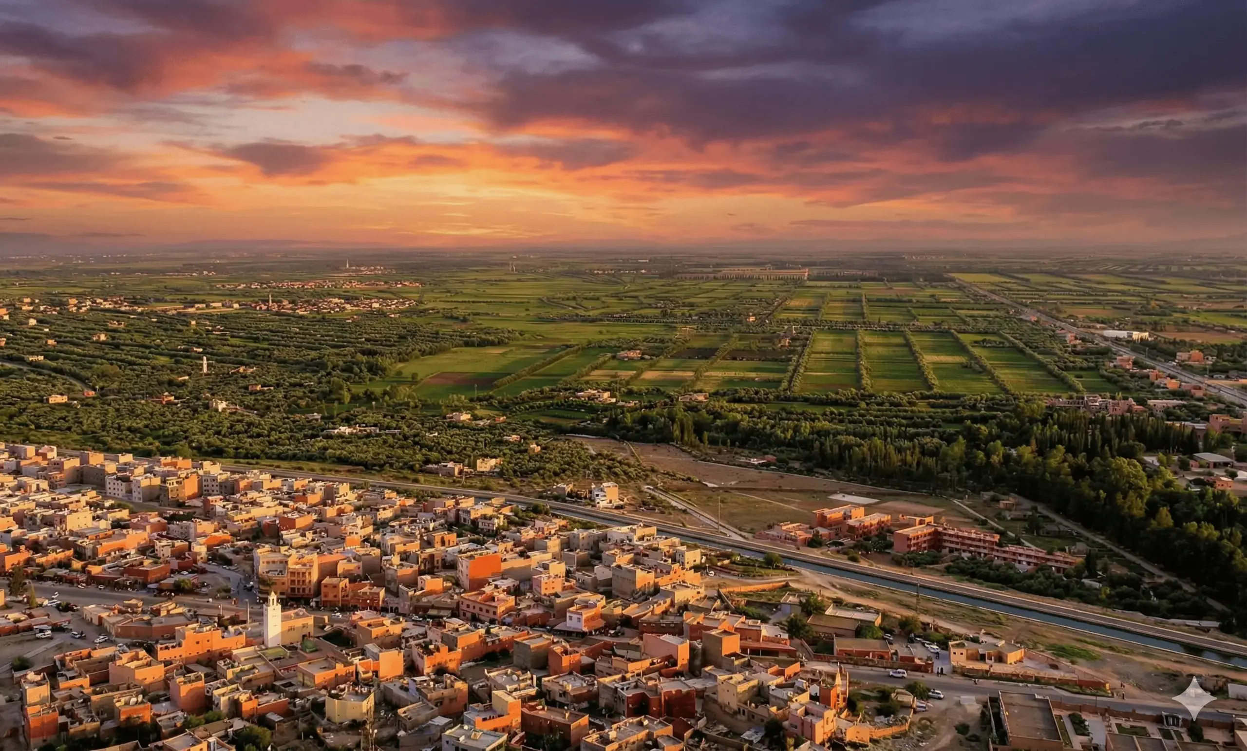
North and west of the town, the Tadla plain runs flat for fifty kilometres: wheat, sugar beet, olives, citrus, all of it laid out in the geometric blocks you can see from the air. South and east, the ground stands up sharply. Within twenty kilometres of the town the road is at 1,000 metres; within sixty, the Aït Bougmez valley sits under 3,000-metre ridges.
Which Atlas?
Afourar is often described as a gateway to the Middle Atlas. That is the wrong range. The mountains directly behind the town — Jbel Tassemit, the Bin El Ouidane basin, the Azilal massif — belong to the Central High Atlas, whose northern front runs along the Tadla. The Middle Atlas begins considerably further north-east, around Khenifra and Azrou.
- Coordinates32.209°N, 6.548°W
- Elevation≈450–500 m
- AdministrativeAzilal Province, Béni Mellal-Khénifra
- Population12,981 (2014 census)
Water
Everything here follows the El Abid
Afourar’s landscape is not natural in the way it looks. The green blocks around it are the product of one river and one dam.
The El Abid rises in the High Atlas and cuts north-west through deep gorges. In 1949 France’s protectorate administration began damming it at Bin El Ouidane, 32 km up the road from Afourar; the 133-metre arch dam was completed in 1953 and impounds roughly 1.5 billion cubic metres.
That reservoir does three jobs at once. It generates electricity at the dam (about 135 MW). It feeds the Afourer pumped-storage station through the Aït Ouarda dam downstream. And through a canal network that crosses the plain past Afourar, it irrigates about 69,500 hectares of the Beni Amir and Beni Moussa perimeters — the reason the Tadla is green at all.
The canal that runs east–west below the town in the photograph above is part of that system. It is also, in practice, the boundary between the built town and the farmland.
- El Abid river
- Bin El Ouidane133 m arch dam, 1949–1953
- Reservoir
- ≈1.5 bn m³one of Morocco's largest
- Irrigated area
- 69,500 haBeni Amir & Beni Moussa perimeters
- Dam output
- 135 MWat Bin El Ouidane itself
Climate
Hot summers, wet springs, cold clear nights
Afourar has a hot semi-arid climate with a marked continental streak: the plain heats up ferociously in summer and the altitude pulls winter nights close to freezing.
| Month | Avg high °C | Avg low °C | Rainfall mm |
|---|---|---|---|
| January | 18.4 | 4.9 | 40 |
| February | 20.5 | 6.6 | 54 |
| March | 22.2 | 8.6 | 81 |
| April | 25.9 | 11.9 | 47 |
| May | 30.8 | 15.6 | 35 |
| June | 34.1 | 18.7 | 6 |
| July | 39.7 | 22.5 | 3 |
| August | 39.3 | 22.9 | 4 |
| September | 34.0 | 19.6 | 7 |
| October | 29.7 | 15.8 | 35 |
| November | 23.5 | 9.9 | 35 |
| December | 20.0 | 6.6 | 36 |
What the numbers mean in practice
July and August average highs just under 40 °C, and the record in the last decade is 47.5 °C. What pushes it that far is the chergui, a dry easterly wind off the interior that can add several degrees in an afternoon. Outdoor work stops in the middle of the day; so should sightseeing.
Winter is mild by day — around 18–20 °C — and genuinely cold at night, occasionally just below freezing. Rooms in small hotels are often unheated, so bring a layer.
Rain averages about 383 mm a year and arrives almost entirely between October and April, peaking in March. Summer is effectively dry. After heavy spring rain, mountain roads towards Azilal can be affected by rockfall and run-off.
For when to come, see the best time to visit.
Getting your bearings